

Ancient Maps
& why they're awesome!

Nowadays, we’re used to seeing world maps featuring countries marked out with bright colours, accurate geographical detail, and — you guessed it — Europe right in the centre at the top. But how did our ancestors look at the world around them, and what of their maps? Here’s a (very) brief introduction to ancient maps…
Finding the oldest known map is a struggle: it’s difficult to agree on what many artefacts represent, and what even counts as a ‘map’ anyway? Contenders include…
25,000 BC - of a region in Czechia, mammoth tusk
20,000 BC - of the Darling river, cylindrical stone (although the estimate also allows as recent as 3,000 BC; sounds like they’re covering their bases)
14,500 BC - of stars, walls of Lascaux caves
12,000 BC - 3d miniature “depicting the functioning of a landscape”, floor of sandstone shelter in the Paris basin
2,200 BC - cadastral plan of West Brittany, stone slab
So no one really knows, but it’s fun to speculate. Things get even more interesting, however, when we look at maps that we’re sure are… maps, like the Babylonian Map of the World from c. the 8th century BC. Turns out the British Museum’s Youtube channel has an excellent video about it, and it’s so good (love Irving Finkel) that you’re much better off watching that than reading a few poorly-informed sentences I’d string together. So let’s get on to Greece & Rome!
Anaximander’s circular map of the world from the 6th century BC features the known lands (Europe, Asia & Libya, though our modern understanding of these names differs significantly) surrounded by ocean. (Because we don’t have the original, we’re relying on descriptions of historians writing much later, like Strabo.) However silly this view seems today, we should remember that trying to explain the world using philosophy and science — rather than mythology — was a big step forward.
Anaximander’s successors continued to develop and correct his ideas, seeking to understand an order they believed was inherent in the universe. Hecataeus, also from Miletus (modern-day western coast of Turkey) produced another in the 5th century BC to accompany the books he wrote to document his travels around the known world, for which reason he is often known as the “father of geography.” You’ll find two reconstructions of these maps below.
Hellenistic maps have much greater scope — Alexander the Great’s campaigns reached as far as India, after all — and begin to recognise the earth as a sphere. They’re all really interesting (and if you’d like to read more I’d recommend checking out Eratosthenes, Posidonius & Ptolemy), but let’s move on to the Romans.

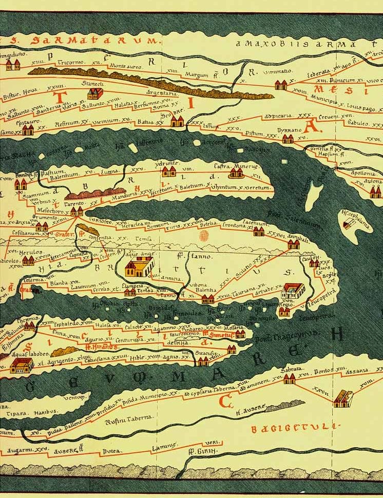
While the Tabula Peutingeriana was produced in c. 1200 AD, many believe that it’s based on a document from c. 400 AD. This itself would been a copy of a famous world map from Augustus’ reign, once engraved in stone and displayed in Rome. As evidence, they cite the inclusion of Pompeii, a large Roman town destroyed by the eruption of Mount Vesuvius in 79 AD and rediscovered in the 16th century. The map also includes states that were formed much later, like Francia in the 5th century AD.
Content-wise, this map is our only extant depiction of the cursus publicus (Roman road network). It’s a wide scroll at 6.75x0.35m, and reads much like our metro maps: land is distorted and geographic features are inaccurate, but roads and their connections are clear. The map features 555 cities and 3,500 other places, with distances between them. There are hundreds of “semi-schematic, semi-pictorial” symbols too, and the biggest/most important cities (Rome, Constantinople and Antioch) are “represented with special iconic decoration”. Look further east, and you can even see India and Sri Lanka.

It’s probably worth ending with something numismatics-related, so here’s a Persian silver Tetradrachm from 359-338 BC featuring… “a relief map of the hinterland of Ephesus.” In 1967, a scholar (Johnston) theorised that this odd incuse reverse might represent “the mountains Tmolos and Messogis between the river valleys of the Caÿster and Maeander, and the three mountain ridges of Madranbaba Dagi, Karincali Dagi, and Akaba Tepesi” from a bird’s eye view, which would make it both the oldest surviving Greek map and the oldest relief map. It’s a very strange claim, and one that many have since refuted for a lack of evidence, but auction houses are all too keen to mention this possibility in the hopes of keeping bidders excited and securing high hammers. It works, too — the coin below sold for 30,000 CHF + bp (although to their credit Numismatica Ars Classica acknowledges the unlikelihood of this map theory).
